But this stunning part of SA has more Mediterranean look about it than just the shape of Italy.
Words & images Chris Blakemore
Gazing over a map of South Australia’s Yorke Peninsula might easily have you thinking you’re planning a visit to Italy’s famous Mediterranean beach resorts – with its strikingly-similar ‘bootish’ outline stepping out into the Southern Ocean.
Aside from the Mediterranean climate and sparkling beaches, that is pretty-much where the Italian similarities begin and end.
With two weeks’ leave from the everyday chores of life, we venture around the more southerly reaches of this lesser-known attribute of Australia’s trademark coastline. Our rig for this journey is our trusty LandCruiser and largish 26-foot caravan. This is important to note, as many of the destinations among the coastal hideaways can accommodate a set-up of this size; but certainly most suit more compact combinations.
However, if planning to venture close to the beachfront, be aware that some roads are mere sandy tracks and an appropriate vehicle and suitably designed and built van are needed in some instances. Motorhome and full-height van owners also need to be conscious of clearance heights in certain locations.
For either interstate or SA-based travellers to the Southern Yorke Peninsula (or ‘SYP’), the journey starts at around Port Wakefield – a small coastal township situated at the very northern point of Gulf St Vincent. Once heading northbound on the A1 Highway, veer off left onto the Copper Coast Highway, and soon enough veer left again onto the Yorke Highway, and your adventure has officially begun. Much of the peninsula is a slender average of 40km wide, so choosing to visit another town or beachfront experience is only a short drive away. The coastal route is approximately 700km in total, but there is much to see and appreciate inland as well as by the shoreline.
One of the more significant towns to be encountered early is Ardrossan, an agricultural and mining port. The real delight of this area is the blue swimmer crab – usually found along the weed-line at the strip of white sand. A most enjoyable aperitif to a Yorke Peninsula holiday.
As you travel further south there are numerous small seaside villages inviting casual visitors to experience their unique local fare and scenery; as well as major towns such as picturesque Port Vincent, renowned for its ‘neat-as-a-pin’ presentation. The furthest point of the boot-leg is where the real beauty and pristine nature of the peninsula comes to the fore – where local roads are unsealed and the ‘scenic route’ signs begin to emerge.
Edithburgh is one of the last stops before traversing the ‘heel and toe’ coastal region. It offers shopping, caravan parks, great fishing options and one of the best small museums in SA. Stocking up here or at the inland township of Yorketown is recommended before venturing off towards the more isolated places across the southern reaches.
A mere 3km from Edithburgh is one of SA’s larger wind farms, a compilation of 55 massive towers harvesting the sea breeze for its energy. Quite an amazing sight to behold are the massive, seemingly slow-moving blades succumbing to even the gentlest of winds… yet the tips of the blades can reach an incredible 220km/h at maximum rotational speed.
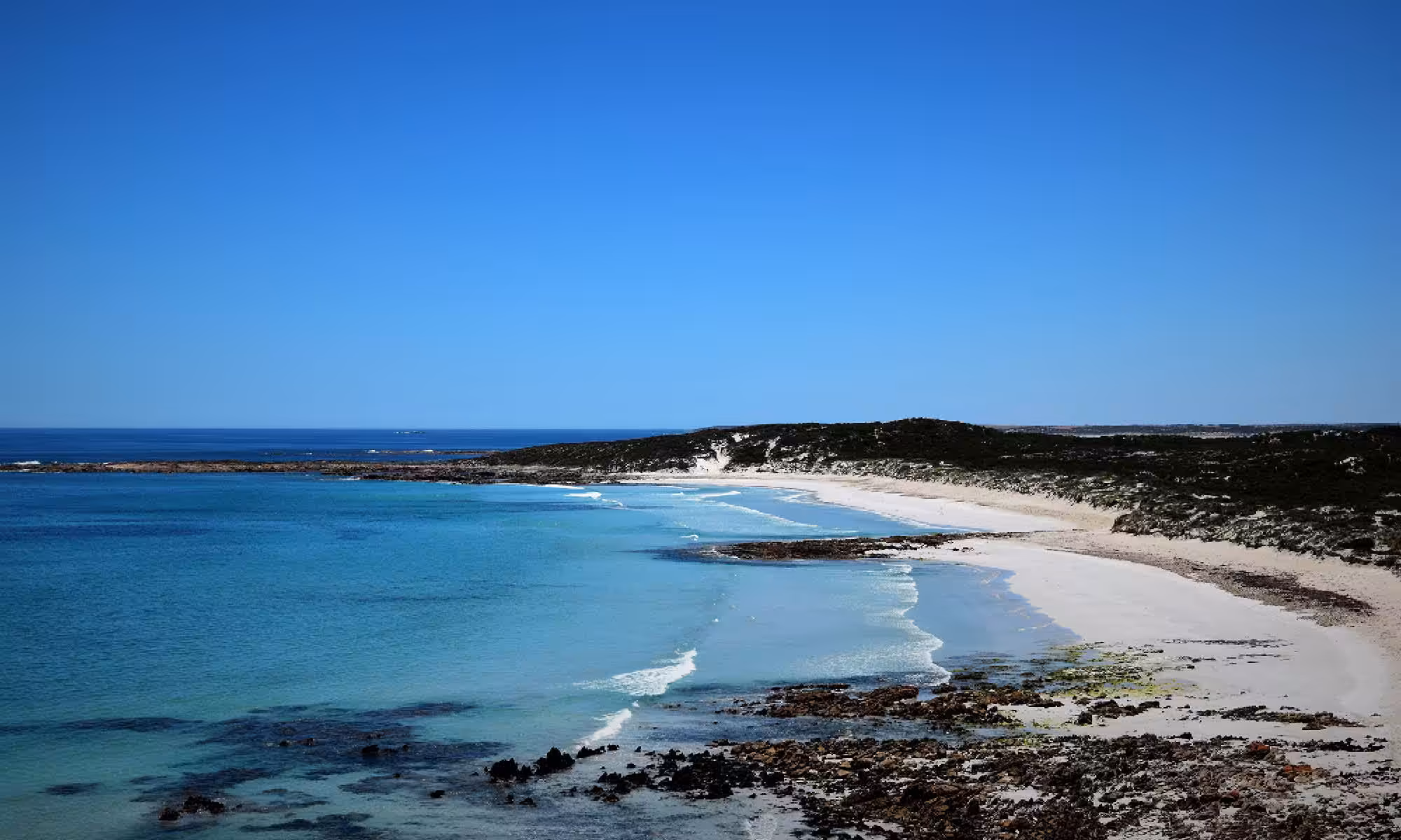
Rather more natural beauty is a short meander down the road where one of the most pristine, secluded beaches awaits the adventurous wanderer, just past the unique ‘wedge-brick’ Troubridge Hill Lighthouse which overlooks the watery grave of some 19 ships and their seafaring souls. The small Kemp Bay is at the very heel of the peninsula and starts at Suicide Point, where a steep staircase will lead you to a long white stretch of beach at the base of a tall cliff face.
A winding gravel road will take you westward towards Port Moorowie, passing many more secluded beaches along the way (but only if you keep an eye out for the small entrance tracks leading off to the side). Many tracks have turning points for vehicles at the edge; but if towing a large van be sure to survey the particular track before heading along any diverging paths.
Port Moorowie is a very small isolated village of few residents and holiday homes, with few facilities available aside from the (4WD-only) boat ramp and some shelter for visitors. The free camp (permits required) at the western edge of town is less frequently visited, given its name of Mozzie Flat. However, it was found to be very inviting and a great place to let the dogs run free for a few moments. A small shelter and parking areas are perfect for a short stay.
More secluded spots to visit and enjoy are dotted along this southerly coastline facing Investigator Strait, and at many points a faint outline of Kangaroo Island can be seen at the horizon. Small shanty ‘towns’ are scattered along the Foul Bay beachfront, although the seaweed leaves an aromatic impression of how that name was bestowed upon the area.
A worthy detour from the South Coast Road, a well-maintained gravel road stretching along this southernmost coastline, takes you to Kangaroo Island Lookout which offers the best clear view of the distant island from the SYP. The next major stop is Marion Bay – a highly-awarded tourist destination and gateway to the Innes National Park. Normal national park entry rules apply with permits available in town. Situated right on the extreme toe of the ‘boot’, this park is a favourite for birdwatching, photography or just bushwalking.
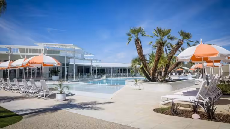
The Marion Bay Caravan Park offers well presented grounds and excellent amenities backed up with friendly service. It is also dog friendly for those travelling with furry family members. The nearby award-winning tavern and general store provides all the basic necessities you may wish to stock up on. For the fishing fanatics among us, the area is renowned for salmon at Brown’s Beach, or mullet off the foreshore and squid off the jetty. There’s also lots of facilities catering to the kids as well – to wash off some of that relentless energy.
Having explored the area, the next-best-kept secrets of the SYP are awaiting just north towards Corny Point. The surfing fraternity loves Daly Head which provides more experienced surfers with some challenging conditions. For the landlubbers there is just as much to see and do, especially if you have a camera at hand and enjoy walking the rocky reefs and sandy beaches. The endangered hooded plover may also be found in this area, but of course it should be left well alone.
Gleesons Landing is a short skip further north and is well worth visiting for caravanners, with ample spaces accommodating all sizes and types. Beware of erosion along the foreshore where the 4WD track leads to another glorious white sandy beachfront. The subtle waves lapping the shoreline are crystal clear and the beach is safe for kids as well – making it a perfect playground for visitors of any age.
The next magical stop on this ‘tour of the toe’ is Swincer Rocks. This place delivers more of the isolated pristine beach areas already encountered. If you find one a little busy, only a short drive will find you another perhaps uninhabited paradise. Many campgrounds and parking areas are conveniently located at these beachfront locations; some with accompanying shelters, toilets and even bins. After following the track north along picturesque Berry Bay you will arrive at the historic but still operating Corny Point Lighthouse, prior to heading east via Dunn Point and into Corny Point proper.
The Corny Point Caravan Park is a great spot to stop and refresh. With the Howling Dog Tavern just around the corner it’s an ideal place to recover, if only briefly. From here we start to head back via the inland route towards Warooka and onto Yorketown. Major shops and facilities are available in Yorketown if you need supplies or services.
An alternative route from Warooka is the west-facing thoroughfare along the ‘shin’ of the SYP boot-leg which also features some beautiful beachside spots, made popular by the easy access from major towns such as Minlaton and Port Victoria. However, our journey was intended to discover the more hidden, lesser-known spots the dedicated RV adventurer seeks out.
If, like our own preferences, you seek to find that little slice of paradise where hardly a footprint may be discovered, clearly the most remarkable, arresting and inconspicuous locations are found across the more distant reaches of the heel and toe of the peninsula. This is where your camera and time will deliver healthy rewards into the memory bank of life’s adventures.
So what are you waiting for? Check out the information links and start making plans to visit one of SA’s most scenic destinations… that delivers that ideal mix of secluded beauty with nearby conveniences to make a perfect holiday.
Destination Details
- Starts at the geographic northern boundary of –34.093208, 137.975419 (approximate) and all areas south to Investigator Strait.
- Major centres are Maitland, Minlaton and Yorketown and Port Vincent.
- Information outlets are available in major centres as well as Ardrossan, Coobowie and Stansbury.
- Entry access permits to Innes National Park can be obtained via www.parks.sa.gov.au or by using the self-serve computer at the Innes NP Natural Resource Centre.
- For avid bushwalkers there’s more than 500km of walking trails throughout the peninsula including short walks, day walks, and town walks – visit www.yorkepeninsula.com.au/trails#WalktheYorke
- Camping permits can be obtained online or at the Minlaton visitors information centre.
- For fishing guides, surfing spots, What’s On, and more great information, visit the Yorke Peninsula website below.